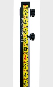
LaserLine GR1000I 10' Ft/Inches Laser Lenker Style Direct Reading Rod
LaserLine GR1000I 10' Ft/Inches Laser Lenker Style Direct Reading Rod (ea)
FLT P/N #:LLMGR1000I  In Stock
List Price:$225.00 Your Price: $179.95
List Price:
 Authorized Dealer
The GR1000I 10' Laser Lenker Style direct reading level rod, gradations in feet/inches, allows you directly observe the true elevation of any point on the job site without any performing any calculations.
Designed for use with a laser level and receiver (it has a track to allow the receiver to slide up and down the rod), the GR1000I can also be used with an optical level.
NOTE: A special LaserLine detector bracket is required to attach your laser receiver to the rod. For Spectra Precision HL450 & HL700 receivers use the LLB-STORM bracket. For Topcon LS-80 receivers use the LLMB1LS70-80 bracket. Other receivers can use the LLMUB-1 Universal Bracket.
All are available separately.
Simply set the reading on the rod to match the elevation of a known elevation such as a benchmark or hub. This is possible because the rod face is actually a continuous flexible tape mounted on rollers within the frame of the rod which can be locked down once set. From then on, every elevation reading around the job site can be read directly by noting where the pointer of your laser detector is when you get the "on grade" signal, or through your optical level.
FEATURES:
The Laser Line GR1000I Direct Reading grade rod is made of high strength clear anodized aluminum for lightweight rugged, dependable operation. It will not rust, split, splinter swell or warp in any environment.
The tape has a heavy duty matte textured face which is easy on the eyes in bright sunlight and protects the tape numbers from wear and fading.
Tape lock grommets are over sized,
heavy duty brass. This greatly minimizes the problem of tape tearing.
Detector rail is black, high density, U.V. stabilized for long life. It is specifically designed to not become brittle when exposed to ultraviolet rays or direct sunlight.
The solid tape lock has an internal brake slide for stronger, trouble-free operation.
DIRECTIONS FOR USING THE GR1000I DIRECT READING ROD:
1. Set rod foot on a benchmark or hub with a known elevation; i.e. 2,525.25 elevation.
2. Run the laser receiver up or down the side of the rod and / or raise or lower front rod section until you get the “on grade” signal on your laser detector. If you are using an optical instrument, site to the rod and use the horizontal line as your grade reference.
3. Loosen the tape lock pin (lower knob) and disengage the tape pin from the grommet.
4. Roll the tape face until 5.25 is across from the pointer on the laser detector bracket, or the horizontal line on your optical instrument. You are using the last whole number and the decimal numbers of 2,525.25.
5. Lock the tape by engaging the tape lock pin into the nearest grommet. Then tighten the knob. You have now locked into the rod elevation (2,525.25). All future readings will be true elevation above or below 2,525.25 (5.25).
6. To find an elevation, simply set the rod foot at any location on the job within the range of your laser or optical instrument. Run the detector and / or front rod section up or down until you pick up the “on grade” signal from your detector. Read the number opposite the pointer. That number is your true elevation. If using an optical instrument, just read the number across the horizontal line. That number is your true elevation.
EXAMPLE:
Rod reading is 6.10 = 2,526.10 true elevation
Rod reading is 8.32 = 2,528.32 true elevation
Rod reading is 4.70 = 2,524.70 true elevation
N/A
View/Download brochure
View/Download directions
Related Products


